Water & Wastewater Infrastructure

Pollution & Sewer Leak Detection by Aerial Infrared

Aircraft-based thermal surveys that locate illicit discharges, sanitary exfiltration, stormwater infiltration, and outfall plumes across municipal and campus water-management networks.

37+ Years

Of Infrared Expertise

50 States

Plus Alaska & Puerto Rico

Aircraft

Not Drones

Engineered

For Facility Decision-Makers

What Is Aerial Pollution and Sewer Leak Detection?

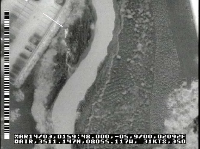
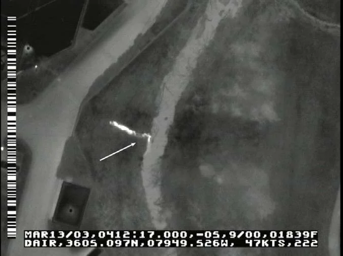
Aerial pollution and sewer leak detection is a non-destructive inspection method that uses aircraft-mounted thermal imaging to identify illicit discharges, sanitary exfiltration, stormwater infiltration, and outfall plumes across a municipal or campus water-management network. Where anomalously-temperature water enters surface waters or leaves a sanitary line, our sensors capture that signature and georeference every finding.

The result is a watershed-scale inventory of every active anomaly across the program, tied to your GIS. Instead of responding to complaints and exceedances, your environmental and engineering teams know which outfalls need attention, which lines need rehabilitation, and where the system is operating as permitted.

We’ve been doing this work for decades using aircraft engineered specifically for thermal collection — not consumer hardware, not adapted equipment. The data is built to support MS4 reporting, NPDES documentation, and capital workflows.

What an Aerial Water Survey Delivers

Illicit Discharge Detection
Thermal mapping of every active outfall along receiving waters within the survey footprint — surfaces discharges that aren’t reported and supports MS4 documentation across the entire watershed.
Exfiltration & Infiltration Mapping
Sanitary exfiltration into surrounding soil and stormwater infiltration into sanitary lines both create thermal anomalies. We capture them ranked by severity and tied to your GIS.
Regulatory-Grade Documentation
Reports formatted for MS4 reporting cycles, NPDES file documentation, and capital request packages. The data is built to support permittee compliance and enforcement workflows.

Built for the Operators of Large Water Networks

Municipal Stormwater Programs
MS4 permittees managing thousands of outfalls across a service area. One survey covers the full receiving-water frontage and identifies active discharges jurisdiction-wide.
Sanitary Sewer Utilities
Wastewater utilities tracking inflow and infiltration across aging collection systems. Aerial coverage locates the major contributors and supports prioritized rehabilitation.
Universities & Campuses
Campus environmental and facilities programs responsible for outfalls to receiving waters and internal sanitary collection — one survey covers both networks.
Industrial & Manufacturing Sites
Facilities under industrial stormwater permits or NPDES discharge monitoring. Thermal evidence supports outfall documentation and exceedance investigations.

Why Aerial Infrared Is the Right Tool for Watershed-Scale Inspection

For a known outfall or a single reach of stream, ground-based thermography and short-range platforms have their place. For a full watershed, the math changes fast — coverage area, tidal and weather windows, and survey conditions all favor aircraft.

A single aircraft mission can scan the full receiving-water frontage of a major municipality or campus in one flight window. Our thermal sensors operate in the spectral bands engineered for water-surface and ground-surface temperature differentials at altitude — not the consumer-grade wavelengths typical of short-range UAS payloads. We fly under the tidal and atmospheric conditions that maximize contrast.

The result isn’t just faster — it’s more consistent. Every outfall and alignment is scanned in the same flight, under the same conditions, with the same sensor. That consistency is what makes the dataset defensible for MS4, NPDES, and capital decisions.

How a Pollution & Sewer Engagement Works

01
Initial Conversation
A working call to understand the program — service area, permit obligations, watersheds of concern, and the decision-makers responsible for compliance and capital planning.
02
Net Meeting
A scoping session with your environmental, engineering, and program leadership where we walk through the methodology, deliverables, and how the survey integrates with your GIS.
03
Scheduled Flight
We schedule the mission around the optimal tidal, weather, and thermal conditions for your watershed. Flight plans and FAA coordination are handled in advance.
04
Engineering Report
A defensible thermal report tied to your GIS, ranking every anomaly by severity, with recommended next actions and supporting documentation formatted for regulatory workflows.

The Cost of Not Knowing Where the Water Is Going

Water-management programs are graded by the regulator on what they know about their network — not on what they hope is true about it. An undetected illicit discharge, an unmapped exfiltration zone, or a stormwater infiltration source can each translate into permit exceedances, enforcement actions, and capital requirements that arrive with no warning.

An aerial infrared survey changes the posture. Instead of responding to complaints and exceedances, your program operates from a watershed-wide inventory of every active anomaly across the network. Most clients recover the cost of the survey through a combination of prevented enforcement risk, prioritized rehabilitation spending, and defensible documentation that strengthens the program’s standing with the regulator and the ratepayer.

There is a third return that often goes unmeasured: the program’s narrative position. Stormwater and sanitary utilities are accountable to elected officials, ratepayer commissions, and increasingly to the public through annual reporting. A documented aerial survey gives the program a fact base for the conversation. Capital requests grounded in thermal evidence are harder to deny; rate adjustments tied to documented network condition are easier to defend; and the stakeholder conversation shifts from anecdote to data. The survey is an investment in the program’s long-term operational and political standing, not just in next quarter’s repair list.

Water-management programs that survey on a defensible cadence are in a structurally stronger position with the regulator, the ratepayer, and the downstream litigation environment than programs that don’t. The survey is an investment in evidentiary posture as much as in operational efficiency, and the value of that posture compounds across every subsequent permit cycle and stakeholder conversation.

Frequently Asked Questions

Discharges into receiving waters almost always carry a different temperature than the receiving water itself. Aircraft-mounted thermal sensors map that contrast across the entire surveyed water frontage. Active outfalls, plumes, and unmapped discharges appear clearly against the background, and each is georeferenced for follow-up. Operators routinely identify outfalls that don't appear on any existing inventory. Every compliance, capital, and stakeholder decision the program supports becomes incrementally more defensible when it's grounded in a current, watershed-scale thermal dataset rather than in complaint logs or partial inspection records. The longitudinal record is what protects the program through permit cycles and enforcement environments.
Sanitary exfiltration warms the soil above the line; stormwater infiltration cools the receiving sanitary network and changes the thermal profile of associated manholes and surface vents. Both create thermal signatures that aerial infrared can identify when the survey is flown under correct conditions. The findings support targeted rehabilitation rather than blanket-replacement programs. The watershed-wide capture is what differentiates the methodology — every outfall and alignment is documented against the same conditions, in the same record, on the same day. That structural advantage is what lets the program operate from a single defensible dataset rather than from a stack of partial inspections.
Coverage and consistency. Aircraft scan an entire watershed under the same tidal, weather, and thermal conditions in a single mission. Drones and ground inspection are useful for a known outfall or a single reach, but as the program scales to watershed level the inconsistency between sessions starts to compound. One mission, one dataset, one set of conditions delivers the defensible posture that MS4 and NPDES programs require. The accuracy of the methodology has been demonstrated across decades of operational work with municipal, industrial, and campus permittees, and the deliverable format has evolved to integrate cleanly with the reporting workflows of the regulator and the program alike.
A typical municipal watershed is scanned across one or two flight windows depending on tidal and weather conditions. Initial ranked findings are delivered within two to four weeks of the survey, with the full report and GIS-ready deliverables shortly thereafter. The program receives a defensible record of the inspection within the same quarter the survey was flown.
Findings are delivered as georeferenced features that import directly into your existing GIS, with metadata fields supporting MS4 outfall inventory, exfiltration tracking, and NPDES file documentation. The format is designed for compliance and capital workflows rather than requiring the program to maintain a parallel data system for the survey results.
Yes. Industrial sites with multiple outfalls or stormwater monitoring obligations use the survey to document outfall locations, confirm dry and wet-weather discharge behavior, and investigate exceedances with thermal evidence that supports compliance reporting. Multi-site operators benefit further from a consistent dataset across the portfolio.

Ready to Inventory Your Watershed?

Tell us about your program. We’ll set up a working session with the right people on your team and walk through how an aerial survey would apply to your specific watershed and compliance footprint.