Commercial Roof Inspection

Aerial Infrared Roof Scanning for Commercial & Industrial Facilities

Aircraft-based thermal inspection that maps subsurface roof moisture across entire campuses, districts, and facility portfolios — in a single survey window.

37+ Years

Of Infrared Expertise

50 States

Plus Alaska & Puerto Rico

Aircraft

Not Drones

Engineered

For Facility Decision-Makers

What Is Aerial Infrared Roof Scanning?

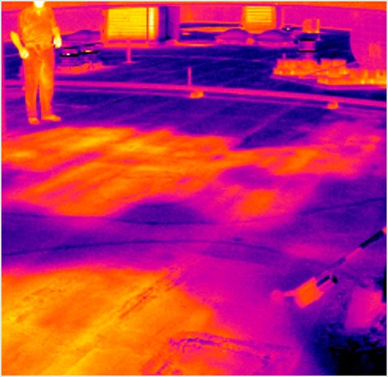
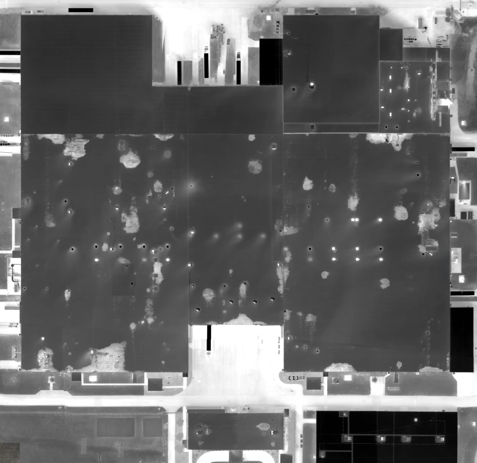
Aerial infrared roof scanning is a non-destructive inspection method that uses aircraft-mounted thermal imaging to identify trapped moisture beneath the membrane of a commercial flat roof. After sundown, a wet roof radiates heat at a different rate than a dry roof — that thermal signature is what our sensors capture, georeferenced to the exact location of the anomaly.

The result is a roof-by-roof map of subsurface moisture across your entire facility portfolio. Instead of guessing where the failures are, your maintenance and capital planning teams know exactly which sections need repair, which need replacement, and which can stay in service. For multi-building campuses, school districts, and large facility operators, it’s the most cost-effective roof intelligence available.

We’ve been doing this work for decades using aircraft engineered specifically for thermal collection — not consumer hardware, not adapted equipment. The data we deliver is built to support engineering specifications, capital budgets, and warranty claims.

What an Aerial Infrared Roof Scan Delivers

Subsurface Moisture Mapping
Every wet area beneath the membrane, georeferenced to its exact location on the roof. No guessing, no probing — just thermal evidence your team can act on.
Portfolio-Wide Coverage
Hundreds of buildings inspected in a single flight window. School districts, university campuses, and multi-site operators get one consistent dataset across their full portfolio.
Defensible Engineering Reports
A formatted thermal report your maintenance team can scope from, your finance team can budget against, and your specifications team can attach to RFPs and warranty claims.

Built for the Facilities With the Most Roof to Inspect

Universities & Colleges
Multi-building campuses with aging membrane roofs and limited maintenance windows. Inspect every roof in a single survey.
K-12 School Districts
District-wide roof intelligence covering every school in a county or independent system — critical input for capital planning and bond cycles.
Hospitals & Health Systems
Critical-environment buildings where roof failures threaten operations, equipment, and patient care. Detect moisture before it reaches the deck.
Roofing Consultants
Independent thermal data to support your moisture surveys, replacement specifications, and engineering recommendations to client owners.

Why Aircraft-Based Infrared Outperforms Other Methods

For small inspections, ground-based thermography and short-range platforms have their place. For multi-acre roof portfolios, the math changes fast — coverage area, sensor wavelength, and survey conditions all favor aircraft.

A single aircraft mission can scan the entire roof inventory of a major university or school district in one night. Our thermal sensors operate in the spectral bands engineered for moisture detection — not the consumer-grade wavelengths typical of small UAS payloads. And because of altitude and aircraft capability, we can collect clean thermal data through more of the year than ground-based or short-range alternatives.

The result isn’t just faster — it’s more consistent. Every roof is scanned in the same flight, under the same conditions, with the same sensor. That consistency is what makes the dataset defensible for engineering and capital planning decisions.

How a Roof Scanning Engagement Works

01
Initial Conversation
A short call to understand your facility, the roofs in scope, and the decision-makers involved on your side.
02
Net Meeting
A working session with your full team — facilities, engineering, finance — where we walk through the methodology and the deliverables specific to your portfolio.
03
Scheduled Flight
We schedule the survey for the optimal thermal window. You receive the flight plan and any site coordination notes well in advance.
04
Engineering Report
A defensible thermal report your maintenance and engineering teams can use to scope repairs, justify budgets, and support warranty claims.

The Cost of Not Knowing Where the Moisture Is

A single saturated section of insulation can compromise the entire roof system long before the failure becomes visible from below. By the time water reaches the deck, the cost has shifted from a contained repair to a partial or full replacement — often four to ten times more expensive than catching the problem early.

Aerial infrared changes the economics. For most clients, the cost of scanning the entire portfolio is recovered by avoiding a single unnecessary replacement, or by extending the service life of a roof that didn’t actually need full tear-off. The data doesn’t just inform maintenance — it protects the capital plan.

Frequently Asked Questions

A typical campus or school district is scanned in a single night. Multi-state or geographically distributed portfolios are scheduled across one or more flight windows depending on weather and travel logistics.
Aerial infrared works best on low-slope and flat commercial roofs — built-up roofs, modified bitumen, single-ply membranes (TPO, EPDM, PVC), and coated systems. Steep-slope and metal-panel roofs aren't reliable candidates for thermal moisture inspection.
When the scan is performed under proper thermal conditions and analyzed by experienced thermographers, infrared reliably identifies moisture-saturated areas warranting repair or replacement. Findings are typically validated with on-roof verification at representative locations.
Roof scans require a specific thermal window — typically a clear evening following a sunny day, with no recent rainfall. Our aircraft-based approach allows us to fly through more months of the year than ground-based methods, but scheduling depends on regional climate and recent weather.
Each report includes a roof-by-roof site map, thermal imagery with anomalies marked, location-specific findings, recommended actions, and supporting documentation suitable for engineering specifications and capital planning.
Most facilities scan on a 2 to 5-year cycle depending on roof age, climate, and maintenance practices. Aging portfolios and properties approaching end-of-life often benefit from more frequent inspection cadences.

Ready to Map Your Roof Portfolio?

Tell us about your facility. We’ll set up a working session with the right people on your team and walk through how an aerial roof scan would apply to your specific portfolio.