High-Temp Hot Water Distribution

High-Temp Hot Water Leak Detection for Districts

Aircraft-based thermal surveys that locate failing HTHW lines, vault losses, and insulation breakdowns across central-plant distribution — the next-generation district energy inspection.

37+ Years

Of Infrared Expertise

50 States

Plus Alaska & Puerto Rico

Aircraft

Not Drones

Engineered

For Facility Decision-Makers

What Is High-Temp Hot Water Leak Detection?

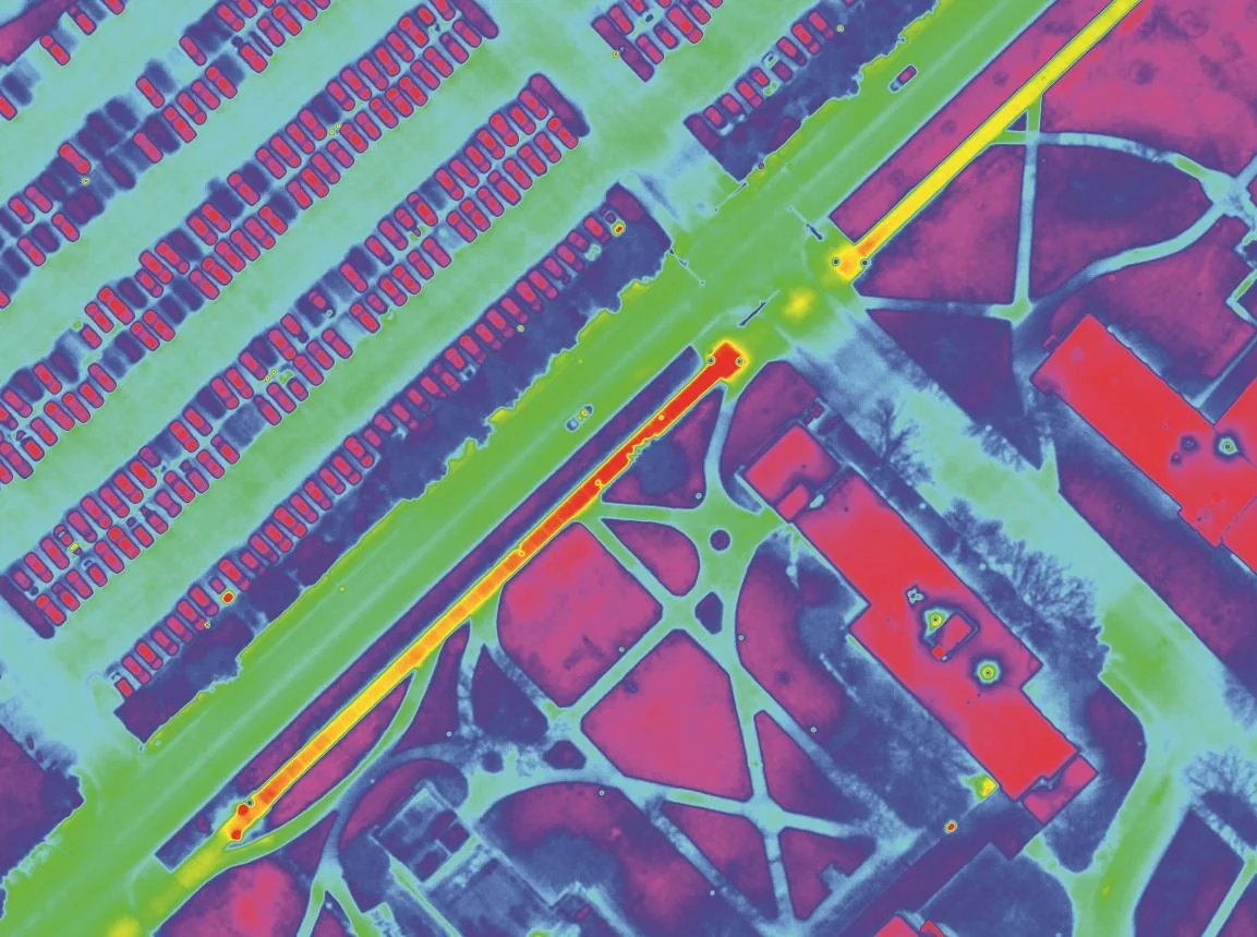
Aerial high-temp hot water leak detection is a non-destructive inspection method that uses aircraft-mounted thermal imaging to identify failing HTHW supply and return lines, vault losses, and insulation breakdowns across a central-plant distribution network. Where the soil column above a leaking or saturated line is warmer than the surrounding ground, our sensors capture that signature and georeference every anomaly.

The result is a network-wide loss inventory tied to your existing as-built drawings, ranked by severity. Instead of waiting for failures to surface, your maintenance and engineering teams know which segments need repair, which need replacement, and which are operating as designed.

We’ve been doing this work for decades using aircraft engineered specifically for thermal collection — not consumer hardware, not adapted equipment. The data is built to support engineering specifications, capital requests, and rate-base or regulatory reporting.

What a High-Temp Hot Water Survey Delivers

Network-Wide Loss Inventory
Every active HTHW loss across the supply and return network, georeferenced to its exact location and tied to your distribution as-builts in a single survey window.
Insulation & Jacket Failure Detection
HTHW losses are often driven by jacket and insulation failure rather than line breach. Thermal mapping detects saturated segments long before they progress to leak.
Capital Planning Documentation
Defensible thermal evidence supporting replacement decisions, upgrade specifications, and rate-base or capital-budget justifications. The data survives engineering and finance review.

Built for the Operators of Modern District Energy

Universities & Colleges
Campus central plants converting from steam to HTHW — or operating new HTHW networks from the ground up. Full-system inspection without disrupting service.
Military Installations
Base-wide HTHW distribution serving barracks, medical, and operational facilities. One inventory of the entire network without coordinating ground access across zones.
Healthcare Campuses
Hospital and medical-center HTHW networks where service interruption is not an option. We identify losses without entering buildings or shutting down clinical operations.
Municipal Energy Utilities
City-owned district heating utilities operating downtown HTHW distribution. One overnight mission replaces a multi-month ground inspection campaign.

Why Aerial Infrared Is the Right Tool for HTHW Networks

For a single vault or a known problem segment, ground-based thermography and short-range platforms have their place. For miles of HTHW supply and return lines, the math changes fast — coverage area, atmospheric consistency, and survey conditions all favor aircraft.

A single aircraft mission can scan the full distribution footprint of a major university, hospital campus, or municipal district energy network in one overnight flight. Our thermal sensors operate in the spectral bands engineered for ground-surface temperature differentials at altitude — not the consumer-grade wavelengths typical of short-range UAS payloads. We fly when contrast against the soil column is sharpest.

The result isn’t just faster — it’s more consistent. Every segment is scanned in the same flight, under the same conditions, with the same sensor. That consistency is what makes the dataset defensible for engineering and capital planning decisions.

How a High-Temp Hot Water Engagement Works

01
Initial Conversation
A working call to understand the network — supply temperature, total distribution miles, plant capacity, known segments of concern, and the decision-makers on your team.
02
Net Meeting
A scoping session with your facilities, engineering, and energy team where we walk through the methodology, deliverables, and how the survey integrates with capital planning.
03
Scheduled Flight
We schedule the mission for the optimal thermal window. Flight plans and ground coordination notes are delivered well in advance, with no required interruption of service.
04
Engineering Report
A defensible thermal report ranking every loss across the network, tied to your distribution drawings, with recommended next actions for repair, replacement, or further investigation.

The Cost of Letting an HTHW Network Drift

High-temperature hot water systems lose heat the same way steam systems lose energy — through insulation jacket failure, saturated runs, vault losses, and pinhole breaches in supply and return lines. The losses are easier to ignore than steam because there’s no visible plume to alert an operator, but the underlying economics are the same: every BTU lost to the soil is fuel burned for nothing.

An aerial infrared survey converts that hidden loss into a ranked, actionable inventory. Your maintenance team works from a network-wide map instead of complaint reports; your engineering team supports capital decisions with thermal evidence rather than estimates. For most HTHW operators, the cost of the survey is recovered through fuel savings within a single operating year, and the prevented emergency repairs compound the return over the life of the network.

The second-order economics matter as much as the fuel savings. HTHW failures under occupied campuses or downtown streets carry consequential damages — slab penetration, root-zone disruption, service-interruption windows, and contractor mobilization costs that dwarf the repair itself. Catching the precursor thermal signature converts an emergency into a planned outage scheduled around the academic calendar, the patient-care schedule, or the seasonal load curve. Each prevented emergency typically covers the cost of multiple future surveys, and the data accumulated across consecutive years supports the kind of trend analysis that ages into a defensible asset-management program rather than a series of point-in-time inspections.

The operators who survey on a defensible cadence run a measurably more efficient distribution system than the operators who don’t. On HTHW networks specifically, the gap is amplified by the insulation-driven failure mode: catching the precursor condition before it becomes line breach is what protects the network from the consequential damage that drives the largest costs. The survey is an investment in efficiency, capital posture, and regulatory standing.

Frequently Asked Questions

Aircraft-mounted thermal sensors map ground-surface temperatures above the buried network. Where heat is escaping from a supply or return line — whether through a pinhole breach, a saturated jacket, or a failing expansion component — the soil column above it runs warmer than the surrounding ground. We capture that signature, georeference it, and grade the anomaly against the rest of the network. Every operational and capital decision the network supports becomes incrementally more defensible when it's grounded in a current thermal dataset rather than in an aging set of assumptions about the network's condition. The longitudinal record is what protects the program through regulatory and rate-base proceedings.
It's a matter of coverage and consistency. Aircraft can scan an entire distribution network in one mission, under the same thermal conditions, with the same sensor calibration. Short-range platforms work well on a single segment or a known problem location, but distribution networks are linear and miles long — by the time multiple drone sorties or ground walks finish, conditions over the earlier segments have already shifted. Aircraft deliver one dataset of one network.
When the mission is flown under correct thermal conditions and the imagery is analyzed by experienced thermographers, aerial infrared reliably identifies active losses across the network. We confirm representative findings with ground verification before recommending excavation, and we rank every anomaly by severity so your team can triage the response. The workflow has been refined across decades of distribution inspection.
A university campus or military installation is typically scanned in a single overnight flight. Multi-square-mile municipal networks are scheduled across one or two flight windows, depending on regional weather and the size of the service area. Initial ranked findings are delivered within two to four weeks of the survey, with the full engineering report shortly after.
No. The aircraft operates at altitude and the survey is flown overnight, so there's no interruption of service, no lane closures, and no ground access required across your facility. Your distribution system remains in normal operating mode throughout the mission. This is one of the larger operational advantages of aerial inspection on critical-environment networks where shutdown is not feasible.
Most large district energy operators benefit from a survey cadence of every two to four years, with more frequent inspection on aging segments or networks approaching end of service life. Operators converting from steam to HTHW typically baseline the new network within the first operating year so that subsequent surveys have a defensible starting point.

Ready to Inventory Your Distribution Losses?

Tell us about your HTHW network. We’ll set up a working session with the right people on your team and walk through how an aerial survey would apply to your specific distribution footprint.