Aerial Wildlife Thermography

Wildlife & Animal Surveys by Aerial Infrared

Aircraft-based thermal surveys that detect, count, and map wildlife populations across large landscapes — supporting natural resource agencies, environmental consultants, and research programs.

37+ Years

Of Infrared Expertise

50 States

Plus Alaska & Puerto Rico

Aircraft

Not Drones

Engineered

For Facility Decision-Makers

What Is Aerial Infrared Wildlife Surveying?

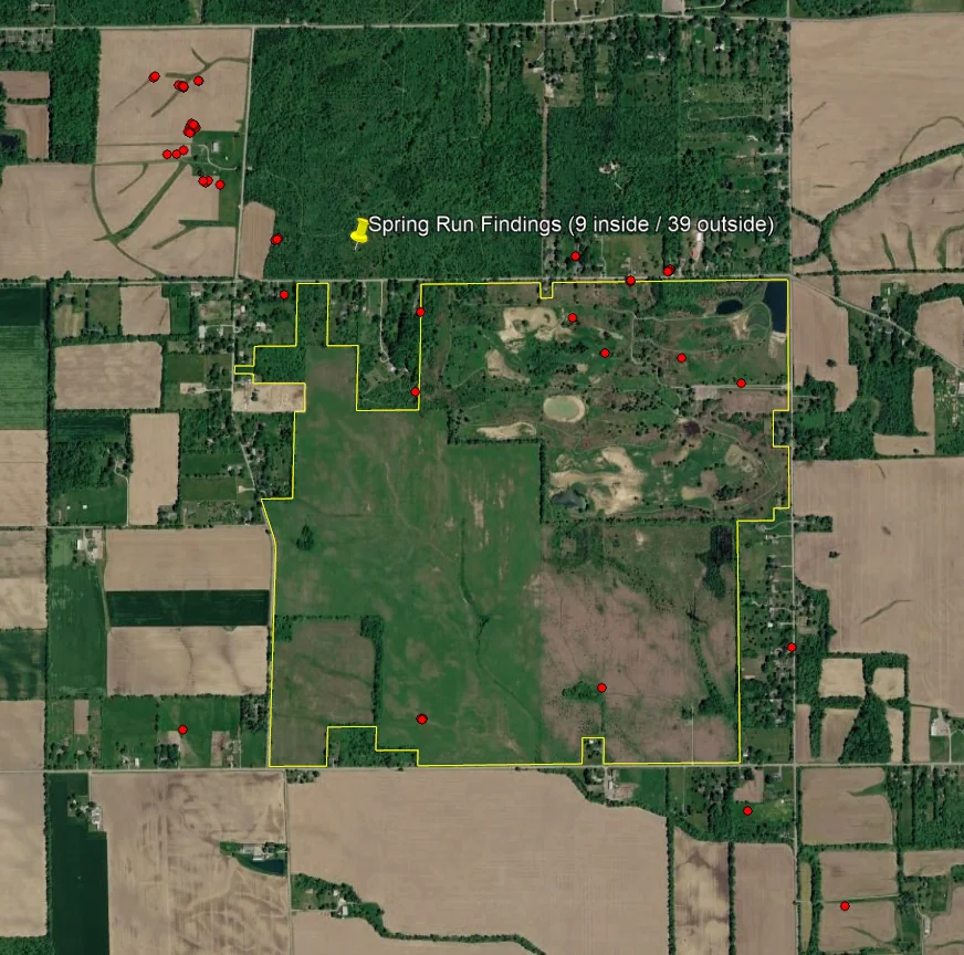
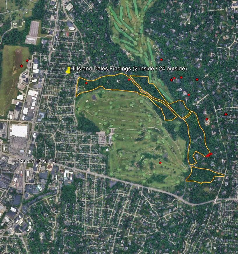
Aerial wildlife surveying is a non-destructive inspection method that uses aircraft-mounted thermal imaging to detect, count, and map warm-bodied animal populations across a working landscape. Where a metabolism produces a thermal contrast against the surrounding ground, our sensors capture that signature day or night, in cover or in the open, and georeference every detection.

The result is a landscape-scale population dataset across the entire study area, georeferenced and classified where the imagery supports it. Instead of accepting the bias of daylight visual counts or the cost of ground transects, your biology and program teams know which areas hold the population, which need management attention, and where habitat use is shifting.

We’ve been doing this work for decades using aircraft engineered specifically for thermal collection — not consumer hardware, not adapted equipment. The data is built to support agency reporting, NEPA documentation, and peer-reviewed research.

What an Aerial Wildlife Survey Delivers

Landscape-Scale Detection
Thermal detections across the entire survey footprint, georeferenced to exact location. The dataset supports population estimates, distribution mapping, and density analysis.
Species or Size-Class Classification
Where imagery supports it, detections are classified by species or size class — useful for differentiating cervids, feral populations, predators, and other thermally-detectable wildlife.
Defensible Program Documentation
Reports formatted for natural resource agency reporting, NEPA compliance, and research publication. The data supports population assessments and stakeholder reporting cycles.

Built for the Programs That Manage the Landscape

State Wildlife Agencies
Population surveys for cervid, predator, and game species across management units and statewide ranges. One mission produces a consistent dataset across the management area.
Federal Land Managers
BLM, USFS, NPS, and USFWS programs surveying wildlife on managed lands. Aerial coverage supports landscape-scale population assessments and inter-agency reporting.
Environmental Consultants
Consulting firms supporting NEPA documentation, wind and solar siting, and infrastructure permitting. Thermal evidence strengthens wildlife impact assessments.
Research Programs
University and independent research programs running long-term population, distribution, or behavioral studies. Aerial surveys deliver consistent data across study cycles.

Why Aerial Infrared Is the Right Tool for Landscape Wildlife Survey

For a small, defined survey footprint, ground-based thermography and short-range platforms have their place. For a management unit, working landscape, or study area, the math changes fast — coverage area, biological window, and survey conditions all favor aircraft.

A single aircraft mission can scan an entire management unit or research area in one pre-dawn flight, capturing every detection under one set of conditions. Our thermal sensors operate in the spectral bands engineered for warm-target detection against terrestrial backgrounds at altitude — not the consumer-grade wavelengths typical of short-range UAS payloads. We fly when ambient temperatures are coolest and contrast is sharpest.

The result isn’t just faster — it’s more consistent. Every detection is captured in the same flight, under the same conditions, with the same sensor. That consistency is what makes the dataset defensible for agency, NEPA, and research decisions.

How a Wildlife Survey Engagement Works

01
Initial Conversation
A scoping call to understand the program — target species, study area, management or research objectives, and the decision-makers across biology, program leadership, and partner agencies.
02
Net Meeting
A working session with your biology, GIS, and program team where we walk through the methodology, deliverables, and how the survey integrates with your population models.
03
Scheduled Flight
We schedule the mission for the optimal thermal and biological window — accounting for species behavior, regional weather, and any access or stakeholder coordination required.
04
Population Report
A defensible thermal report with every detection georeferenced, classified where the imagery supports classification, and formatted for population analysis and agency reporting.

The Cost of Working From Bad Population Data

Wildlife programs operate on numbers — population estimates, harvest quotas, mitigation requirements, NEPA findings. When the underlying count is uncertain, every downstream decision inherits that uncertainty. Daylight visual counts are known to undercount in cover-rich landscapes. Ground transect data is expensive to scale across a management unit. Stakeholder-facing assessments that depend on stale or partial data don’t survive their first serious challenge.

Aerial infrared changes the math. Instead of accepting the bias and noise of conventional methods, your program operates from a landscape-scale dataset captured under controlled conditions. Most programs recover the cost of the survey through better harvest management, defensible mitigation reporting, and stronger footing in stakeholder and regulatory discussions — the kind of return that compounds across multiple management or research cycles.

There is a less-visible return that often justifies the survey on its own: program credibility. Wildlife programs operate under scrutiny from sportsmen and women, conservation groups, agricultural stakeholders, energy developers, and political leadership. The defensibility of the program’s numbers is the defensibility of the program itself. A documented aerial survey creates evidence the program can produce when the count is challenged — and the existence of that evidence often forecloses the challenge entirely. Over time, programs that survey on a defensible cadence build the kind of track record that protects their funding, their harvest authority, and their long-term ability to manage the landscape.

Wildlife programs that survey on a defensible cadence operate with materially stronger defensibility, materially better harvest management, and materially lower long-run cost than programs that mix methods or depend on intermittent counts. The survey is an investment in the program’s data foundation, and that foundation is the foundation of everything else the program does.

Frequently Asked Questions

Most thermally-distinguishable warm-bodied wildlife — cervids (deer, elk, moose), feral and agricultural species, predators, ground-roosting birds, and similar size classes. The species and landscape together determine what classification the imagery supports, and we work with the program's biology team during scoping to align expectations. Every harvest, habitat, mitigation, and stakeholder decision the program supports becomes incrementally more defensible when it's grounded in a current, landscape-scale thermal dataset rather than in method-mixed historical counts. The longitudinal record is what protects the program through every public-trust and political challenge.
Coverage and consistency. Aircraft scan an entire management unit, study area, or working landscape in a single mission under one set of biological and atmospheric conditions. Short-range platforms are well suited to a small, defined survey footprint, but landscape-scale work requires the altitude and endurance of an aircraft to deliver a comparable dataset. The landscape-scale capture is what differentiates the methodology — every habitat block and detection is documented against the same conditions, in the same record, on the same flight. That structural advantage is what lets the program build a population estimate that survives peer review and stakeholder challenge.
Under proper survey conditions, aerial infrared has consistently demonstrated higher detection rates than daylight visual aerial counts, particularly in cover-rich landscapes. Standard biostatistical methods can be applied to the detection data to produce defensible population estimates and confidence intervals suitable for agency reporting and peer review. The accuracy of the methodology has been demonstrated across decades of agency, federal land management, and research work, and the deliverable format has evolved to integrate cleanly with the population analysis and agency reporting workflows the program actually runs.
Most wildlife surveys are scheduled for the cool season, with missions flown pre-dawn or early morning when ambient temperatures are coolest and thermal contrast with active wildlife is sharpest. The exact window depends on the target species and the study area, and we work with the program's biology team to identify the best window. The window selection process is part of the survey methodology, and the biology team's species-specific knowledge is integrated into the flight plan before the mission is scheduled. That coordination is what produces a defensible count rather than a generic aerial inspection.
Aircraft operate at altitudes engineered to minimize disturbance to wildlife populations. We coordinate flight planning with the study program's biological team to address species-specific sensitivities and any agency-imposed flight restrictions over the survey area. The methodology has decades of operational history without documented population-level impact.
Each report includes a georeferenced detection dataset, thermal imagery supporting representative findings, classification where the imagery supports it, and supporting documentation formatted for the program's reporting cycle — agency, NEPA, or research publication. The deliverable is designed to integrate with the program's existing analysis workflow.

Ready to Survey the Landscape?

Tell us about the program. We’ll set up a working session with the right people on your team and walk through how an aerial infrared wildlife survey would apply to your specific study area.