Solid Waste Site Inspection

Landfill Fire & Methane Detection by Aerial IR

Aircraft-based thermal surveys that locate subsurface combustion, smoldering events, and methane emission anomalies across municipal and industrial landfill sites.

37+ Years

Of Infrared Expertise

50 States

Plus Alaska & Puerto Rico

Aircraft

Not Drones

Engineered

For Facility Decision-Makers

What Is Aerial Landfill Fire and Methane Detection?

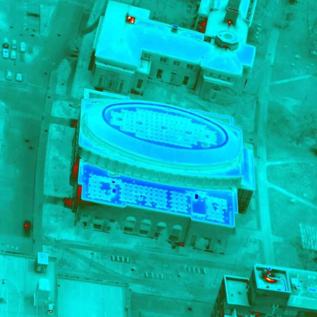
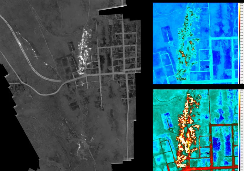
Aerial landfill fire and methane detection is a non-destructive inspection method that uses aircraft-mounted thermal imaging to identify subsurface combustion, smoldering events, and methane emission anomalies across an entire solid waste site. Where the waste mass is warmer than designed, or gas is migrating outside the gas collection footprint, our sensors capture that signature and georeference every anomaly.

The result is a site-wide inventory of every thermal and emission anomaly across the landfill, tied to your operations and GCCS drawings. Instead of waiting for surface symptoms to appear, your compliance and engineering teams know which zones need investigation, which require GCCS adjustment, and where the site is operating as designed.

We’ve been doing this work for decades using aircraft engineered specifically for thermal collection — not consumer hardware, not adapted equipment. The data is built to support air-quality reporting, combustion-prevention programs, and post-closure stewardship.

What a Landfill Survey Delivers

Subsurface Combustion Detection
Elevated-temperature zones within the waste mass indicating smoldering, oxidation, or active subsurface fire — captured across the entire site footprint and ranked by thermal intensity.
Methane Anomaly Mapping
Surface thermal anomalies associated with gas migration outside the design footprint of the collection system. Data supports GCCS troubleshooting and regulatory reporting.
Site-Wide Compliance Documentation
Reports formatted for solid waste regulatory reporting, air quality program documentation, and post-closure site stewardship. The data supports operations and compliance workflows.

Built for the Operators of Active and Closed Sites

Municipal Solid Waste Operators
Cities, counties, and authorities operating active MSW landfills with gas collection systems in place. One mission inventories subsurface and surface anomalies site-wide.
Private Landfill Operators
National and regional waste companies operating active sites under air quality and combustion-prevention obligations. Aerial coverage supports compliance reporting.
Post-Closure Stewards
Stewards of closed and capped landfills — typically municipal or host-community programs — responsible for long-term monitoring and stewardship of legacy sites.
Environmental Consultants
Consulting firms supporting solid waste clients on regulatory, operational, or capital matters. Aerial thermal data strengthens investigations and design recommendations.

Why Aerial Infrared Is the Right Tool for Landfill Sites

For a single cell or a known anomaly, ground-based thermography and short-range platforms have their place. For a full site or a multi-site portfolio, the math changes fast — coverage area, hazard exposure, and survey conditions all favor aircraft.

A single aircraft mission can scan the entire footprint of a municipal solid waste site in one flight window, with no ground-personnel exposure to subsurface combustion or gas hazards. Our thermal sensors operate in the spectral bands engineered for ground-surface temperature differentials at altitude — not the consumer-grade wavelengths typical of short-range UAS payloads. We fly when ambient atmosphere supports sharpest contrast.

The result isn’t just faster — it’s more consistent. Every cell is scanned in the same flight, under the same conditions, with the same sensor. That consistency is what makes the dataset defensible for regulatory, operational, and stewardship decisions.

How a Landfill Engagement Works

01
Initial Conversation
A scoping call to understand the site — operational status, footprint, gas collection system, known concerns, and the decision-makers across operations, compliance, and engineering.
02
Net Meeting
A working session with site operations, compliance, and engineering leadership where we walk through the methodology, deliverables, and how the survey integrates with your GCCS.
03
Scheduled Flight
We schedule the mission for the optimal thermal window across the site, with any required FAA coordination handled in advance. Operations continue normally during the survey.
04
Site Anomaly Report
A defensible thermal report ranking every anomaly across the site, tied to your operations and GCCS drawings, with recommended next actions for investigation or system adjustment.

The Cost of Letting a Landfill Surprise You

Landfill problems escalate. A small subsurface oxidation event discovered late becomes a multi-month combustion response with engineered intervention, regulator coordination, and host-community fallout. A drifting methane signature outside the GCCS footprint becomes a Title V exceedance, a Subpart Cf report, or a capital request for system expansion that arrives with no warning. The cost of late discovery is almost always an order of magnitude higher than the cost of early intervention.

Aerial infrared converts late discovery into early intervention. Instead of waiting for symptoms to surface, the operator works from a site-wide thermal inventory captured under controlled conditions. Most programs recover the cost of the survey through avoided combustion response, prioritized GCCS adjustments, and stronger documentation in front of the regulator and the host community — the kind of return that compounds across the operational life of the site.

There is a third-order return that solid waste operators often discount until they need it: legal and insurance exposure. Subsurface combustion events at active landfills attract regulator response, host-community attention, and, increasingly, civil claims from adjacent property owners and downwind communities. Operators who can demonstrate documented thermal surveying on a defensible cadence are in materially better position to manage that exposure than operators who discover the event through public reporting. The survey is, among other things, evidence the operator was actively monitoring — and that evidence is among the strongest defenses available in the post-event environment.

Operators who run aerial inspection on a defensible cadence operate materially safer, materially better-documented, and materially more defensible sites than operators who don’t. The gap shows up in avoided combustion response cost, in stronger regulator and host-community standing, and in materially better posture against post-event legal and insurance exposure. The survey is an investment in the operational, compliance, and legal foundation of the site.

Frequently Asked Questions

Subsurface oxidation and combustion events warm the waste mass and the surface above it. Aircraft-mounted thermal sensors map those elevated-temperature zones across the site, and the imagery is analyzed against the site's operational history and GCCS layout to identify candidates for investigation or response. Early-stage events are detectable long before surface smoke appears. Every compliance, operational, and legal decision the site supports becomes incrementally more defensible when it's grounded in a current, site-wide thermal dataset rather than in surface observation alone. The longitudinal record is what protects the operator through every regulatory cycle, host-community challenge, and post-event environment.
Surface thermal anomalies associated with gas migration outside the GCCS design footprint are identifiable in aerial infrared and, with the appropriate sensor package, can be characterized with methane-specific data. The results support Subpart Cf, Title V, and state air program reporting workflows, and integrate with the site's existing compliance documentation. The site-wide capture is what differentiates the methodology — every cell, the working face, and the perimeter are all documented against the same conditions, in the same record, on the same flight. That structural advantage is what lets the operator manage the site from a single defensible dataset rather than from a series of partial inspections.
Coverage area, condition consistency, and safety. Aircraft scan the entire site footprint in a single mission under the same thermal conditions, with no exposure of ground personnel to the site hazards. Short-range platforms work well on a single cell or a known anomaly, but scaling to full-site or portfolio inspection introduces dataset inconsistency that aircraft simply don't have. The accuracy of the methodology has been demonstrated across decades of active and post-closure landfill inspection, and the deliverable format has evolved to integrate cleanly with the air-quality, combustion-prevention, and stewardship workflows the operator runs.
A typical municipal solid waste site is scanned in a single flight window. Multi-site portfolios are scheduled across one or several flight days depending on geography and weather. Initial ranked findings are delivered within two to four weeks of the survey, with the full engineering report following shortly after.
Yes. The aircraft operates at altitude and the survey requires no ground access, so site operations — landfill working face, haul roads, leachate management, and gas collection — continue normally throughout the mission. This is one of the structural advantages of aerial work on active solid waste sites.
Most operators benefit from a survey cadence of every one to three years on active sites, with more frequent inspection on sites with known combustion history, recent GCCS expansion, or elevated regulatory attention. Closed sites typically transition to a longer cadence aligned with the post-closure stewardship plan.

Ready to Inspect Your Site?

Tell us about the landfill. We’ll set up a working session with the right people across operations, compliance, and engineering and walk through how an aerial survey would apply to your site.